The Building of Aslan
Lake Casitas
Updated 7/16/01
The Building of Aslan |
Lake Casitas Updated 7/16/01 |
|
|
Sailing |
|
|
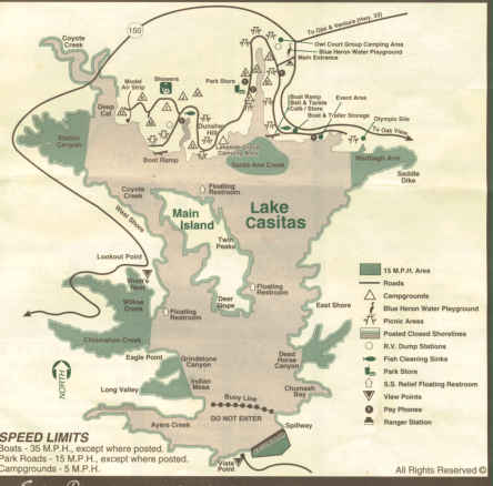
Lake Casitas is located in Ventura, CA, in the hills near Ojai off state highway 33 (which you can reach from the 101 freeway.) It is a beautiful area, wooded with live oak and other native plants. The lake is managed by the Casitas Municipal Water District for drinking water, so some restrictions on use are in place. First, there is no "body contact" with the water, so you don't have water skiing going on, or swimming. It is a prime fishing spot for large mouth bass, so most of the traffic on the lake (at least while I was there) were friendly fishermen who took their bass boats out to a secluded nook somewhere along the "coastline" of the lake or main island. Camping is available, with coin operated showers and some spaces with electrical and water.
Boats are limited to a minimum of 11', and no larger than 24' in length, and must have 48" minimum width. Maximum speed for the power boats is 35 MPH (Weekenders are limited to hull speed, of course, which is about 5 - 7 knots, so those guys can go a lot faster than you.) Canoes, kayaks and "certain inflatables" are permitted also, if they meet some requirements not listed in the brochure.
On July 14, 2001, we enjoyed some wide open sailing. Winds racing north were to 15 - 20 MPH, with a "slot" near the area marked "Coyote Creek" on the map below. Sailing from in front of the Main Island westward towards this slot, we found ourselves in very light winds. As you clear the island's "shadow," the wind is blowing very fast. I suspect there's a sort of venturi effect. We only had two and a half hours to sail, so we didn't try circumnavigating the island.
There are two launch ramp areas at Casitas, the best one is reached by turning right after paying your fee and entering (our single truck and boat cost $12.50 total for the day.) On the map below, this ramp area is just above the "Coyote Creek" designation. The other ramp, which we used in our ignorance, is located near the green "Santa Ana Creek" indication on the map. It has one long dock, with several short ones about 8' long, with large eyebolts rather than cleats. Almost too short to launch Aslan. The ramp is steep, and we were able to float her off the trailer, but had to tie her off across the end to lower the rudder. Docking her was, to say the least, interesting. In contrast, the ramp to the west has several long docks, with real cleats, suitable for actually launching a boat. And I imagine it would make docking the boat after sailing a lot less like a Marx Brothers movie.
On a sunny Saturday afternoon in mid-July, this lake was not crowded
at all. The only times we had anyone near us was when people cruised
over to take a look at Aslan. The Park Ranger hailed us, telling
us not to let loose any "eight pounders" (cannon balls, you know.)
As we drifted past him, he said he liked Aslan's lines, and built models
of old square riggers which he displays at the Ventura County Fair (we'll
have to look him up next time the fair is operating.)
 |
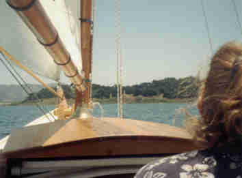 |
Jan looks off toward Main Island as we sail towards it. On the left, in the background, you see the type of mountains surrounding Lake Casitas on all sides, proving a pretty nice view for a California lake. On Main Island are the native California Live Oak trees. The shoreline has numerous nooks perfect for the bass fishermen to troll into and fish for wide mouth bass. |
|
|
Sailing |
|
|